Note: This article won't make sense to anyone outside of South Osaka.
Since the bypass (car-only tunnel) on National Route 480 opened,
Nabeyatani Pass became the old road in place of it, and it's been completely repaired (for us).
I finally made it out there.

At the summit around 4 AM.
The sign was tilted, so I tried to straighten it,
but it must be missing a nail or something—it just goes right back to the angle in the photo.

This is a shot looking back toward the Osaka side
after going just barely into the Wakayama side.
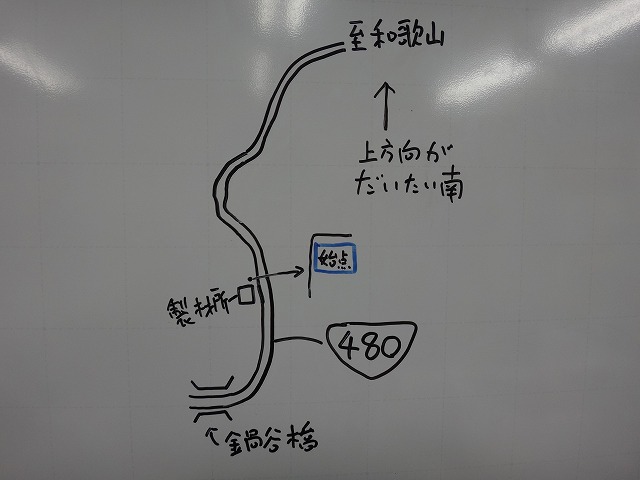
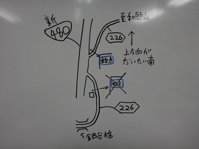
About Nabeyatani Pass though...
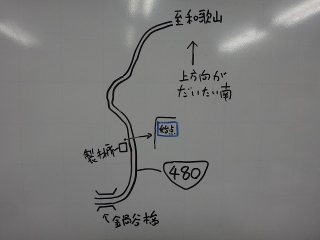
Before the new road was built,
people had different opinions on where the timing for the pass started.
Some would start from Nabeyatani Bridge,
while others started from directly under the blue sign
at a lumber mill a bit further up—the one that warned
"we'll close this section in case of heavy rain."
There were basically two different starting points.

I was in the lumber mill camp.
(When a bunch of us gathered, it was less in the way of cars than the bridge,
and there was shade, so it was relatively cool even in summer.)
The time from the bridge to the lumber mill was about 40 seconds, depending on the person,
so when the starting point didn't match and conversation got confusing,
you could just add or subtract 40 seconds and things would line up.
But now that the bypass has opened, all that has changed.
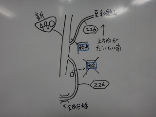
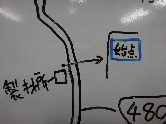
The old National Route 480 is now Prefectural Road 226,
and just past those two old starting points,
the new Route 480 comes thundering through.
If you start from the old starting point,
you end up running on the new Route 480 for just a bit,
but riding the wrong way is dangerous, so you have to cross over the road,
then cross back again to get onto Road 226,
which is dangerous when cars are coming.
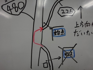
The blue weather sign's starting point has also moved
to where you re-enter Road 226,
so that's probably the safer place to start from now on.
From the new blue sign onward, it's a completely straight single road all the way to Wakayama.
The finishing sign is the same as it's always been—
two corners before the summit at the prefectural border.
So I rode it, and I was shocked at how beautifully paved it is.
Before the repairs, there were rough patches everywhere,
with shallow holes like dinosaur footprints where the asphalt had peeled off,
and lots of sections where the bottom was gravel.
If you're in a group or paying attention to cars, you pretty much have to hit those holes straight on.
It doesn't break your rim outright,
but climbing out of those holes wastes energy on your legs.
After the repairs, there's none of that anymore.
On the climb it's fine, but on the descent it's dangerous, so I used to memorize every location,
but thankfully all that knowledge is now useless.
In the old lumber mill start days,
the spot where the statue of Jizō is was about 1/3 of the total time,
and where the yellow staple-shaped ladder handles
are attached to the concrete embankment on the right and the gradient clearly eases
was about 2/3 of the total time.
In terms of distance rather than time, the lumber mill to Jizō section is just under 30%.
Since Nabeyatani Pass has a slightly easier gradient in the second half,
the 1/3 time point hasn't reached the 1/3 distance mark.
If you run hard at high intensity up to the Jizō,
and maintain that intensity to the end, roughly three times the time to Jizō
gives you your goal time (for the lumber mill start).
But now that the starting point has changed and the pavement is pristine,
the way you'll ride has changed too, so times should drop significantly.
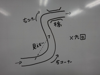
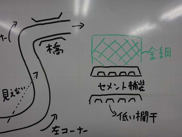
On the descent, after a blind left corner
comes a right corner crossing a small bridge,
and this pattern just repeats endlessly.
As I mentioned, the upper part of Nabeyatani Pass has an easier gradient,
but there's no point where you clearly transition to descending,
and there are almost no flat sections,
so going down from the summit toward the Osaka side
you can coast all the way to the starting point without pedaling.
Descending just after 4 AM on a VOLT 800 (bike light) in high mode is still pretty dark,
so I coasted almost the entire way,
but with blind left curves appearing one after another so quickly,
my right leg stayed stuck at the bottom of the pedal stroke,
and when I wasn't switching legs through the bridge's right corner,
the back of my right knee started to go numb.
Back in the day, I'd blast down the unrepaired descent
full-throttle with the racing mentality going full pedal,
but I don't have the confidence to do that now.
Before the repairs, there were shallow holes everywhere,
and the asphalt directly under the guardrail was collapsing,
making an already narrow road even narrower in places,
but after the repairs that's almost completely gone.
This was always the case, but once you're on the mountain road (past the starting sign),
there are no manhole covers or grates,
so you can descend with a circuit-like feeling.
This does have its own dangers though—when a road is rough or damaged,
you pay extra attention, which actually makes you less likely to crash.
A descent where you can easily reach speeds beyond your limits
has a much higher serious injury rate if you do crash.
The descent at Suisen-gō (daffodil garden) on Awaji Island is a good example
(there really are a lot of stories about people breaking bones there).
When descending, I always count how many times this corner repeats,
how many times 'n' equals in the diagram above,

but midway through, the sheep in my head keep jumping over fences
while pulling off "Toki Soba" tricks on me, so it always gets muddled.
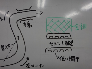
Except for the lower ones, the bridges are mostly concrete paved
(I misspelled it as "hōsō" in the diagram above, but never mind that).
They have low concrete railings on both sides,
and most have green mesh fencing.
There used to be a step between the asphalt and concrete entering each bridge,
which would catch your speed going up and make you bounce and slip on descent corners,
and depending on the season, fallen leaves would hide the step,
making it pretty treacherous,
but the repairs smoothed all those steps out nicely.
Now that the bypass is open, the main factor causing wear and tear on this old road
won't be traffic load but rather weathering and time,
so the asphalt should stay in good condition for a good long while.
Plus, I'm grateful that the bypass
essentially restored one more descent option on the way back from Kōya,
or rather, it opened back up after being closed.
I no longer need to loop all the way to Kimi Pass
after going down Route 480 from Yatate Teaya toward Mishima Onsen,
and besides, from Kimi Pass, depending on the time of day,
the traffic on Route 310 afterward gets absolutely insane,
so I don't want to ride it in the evening.
(Coming down Nabeyatani and onto Senboku Line 2, there isn't nearly as much traffic.)
Since the bypass (car-only tunnel) on National Route 480 opened,
Nabeyatani Pass became the old road in place of it, and it's been completely repaired (for us).
I finally made it out there.

At the summit around 4 AM.
The sign was tilted, so I tried to straighten it,
but it must be missing a nail or something—it just goes right back to the angle in the photo.
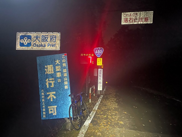
This is a shot looking back toward the Osaka side
after going just barely into the Wakayama side.
About Nabeyatani Pass though...
Before the new road was built,
people had different opinions on where the timing for the pass started.
Some would start from Nabeyatani Bridge,
while others started from directly under the blue sign
at a lumber mill a bit further up—the one that warned
"we'll close this section in case of heavy rain."
There were basically two different starting points.
I was in the lumber mill camp.
(When a bunch of us gathered, it was less in the way of cars than the bridge,
and there was shade, so it was relatively cool even in summer.)
The time from the bridge to the lumber mill was about 40 seconds, depending on the person,
so when the starting point didn't match and conversation got confusing,
you could just add or subtract 40 seconds and things would line up.
But now that the bypass has opened, all that has changed.
The old National Route 480 is now Prefectural Road 226,
and just past those two old starting points,
the new Route 480 comes thundering through.

If you start from the old starting point,
you end up running on the new Route 480 for just a bit,
but riding the wrong way is dangerous, so you have to cross over the road,
then cross back again to get onto Road 226,
which is dangerous when cars are coming.
The blue weather sign's starting point has also moved
to where you re-enter Road 226,
so that's probably the safer place to start from now on.
From the new blue sign onward, it's a completely straight single road all the way to Wakayama.
The finishing sign is the same as it's always been—
two corners before the summit at the prefectural border.
So I rode it, and I was shocked at how beautifully paved it is.
Before the repairs, there were rough patches everywhere,
with shallow holes like dinosaur footprints where the asphalt had peeled off,
and lots of sections where the bottom was gravel.
If you're in a group or paying attention to cars, you pretty much have to hit those holes straight on.
It doesn't break your rim outright,
but climbing out of those holes wastes energy on your legs.
After the repairs, there's none of that anymore.
On the climb it's fine, but on the descent it's dangerous, so I used to memorize every location,
but thankfully all that knowledge is now useless.
In the old lumber mill start days,
the spot where the statue of Jizō is was about 1/3 of the total time,
and where the yellow staple-shaped ladder handles
are attached to the concrete embankment on the right and the gradient clearly eases
was about 2/3 of the total time.
In terms of distance rather than time, the lumber mill to Jizō section is just under 30%.
Since Nabeyatani Pass has a slightly easier gradient in the second half,
the 1/3 time point hasn't reached the 1/3 distance mark.
If you run hard at high intensity up to the Jizō,
and maintain that intensity to the end, roughly three times the time to Jizō
gives you your goal time (for the lumber mill start).
But now that the starting point has changed and the pavement is pristine,
the way you'll ride has changed too, so times should drop significantly.

On the descent, after a blind left corner
comes a right corner crossing a small bridge,
and this pattern just repeats endlessly.
As I mentioned, the upper part of Nabeyatani Pass has an easier gradient,
but there's no point where you clearly transition to descending,
and there are almost no flat sections,
so going down from the summit toward the Osaka side
you can coast all the way to the starting point without pedaling.
Descending just after 4 AM on a VOLT 800 (bike light) in high mode is still pretty dark,
so I coasted almost the entire way,
but with blind left curves appearing one after another so quickly,
my right leg stayed stuck at the bottom of the pedal stroke,
and when I wasn't switching legs through the bridge's right corner,
the back of my right knee started to go numb.
Back in the day, I'd blast down the unrepaired descent
full-throttle with the racing mentality going full pedal,
but I don't have the confidence to do that now.
Before the repairs, there were shallow holes everywhere,
and the asphalt directly under the guardrail was collapsing,
making an already narrow road even narrower in places,
but after the repairs that's almost completely gone.
This was always the case, but once you're on the mountain road (past the starting sign),
there are no manhole covers or grates,
so you can descend with a circuit-like feeling.
This does have its own dangers though—when a road is rough or damaged,
you pay extra attention, which actually makes you less likely to crash.
A descent where you can easily reach speeds beyond your limits
has a much higher serious injury rate if you do crash.
The descent at Suisen-gō (daffodil garden) on Awaji Island is a good example
(there really are a lot of stories about people breaking bones there).
When descending, I always count how many times this corner repeats,
how many times 'n' equals in the diagram above,
but midway through, the sheep in my head keep jumping over fences
while pulling off "Toki Soba" tricks on me, so it always gets muddled.
Except for the lower ones, the bridges are mostly concrete paved
(I misspelled it as "hōsō" in the diagram above, but never mind that).
They have low concrete railings on both sides,
and most have green mesh fencing.
There used to be a step between the asphalt and concrete entering each bridge,
which would catch your speed going up and make you bounce and slip on descent corners,
and depending on the season, fallen leaves would hide the step,
making it pretty treacherous,
but the repairs smoothed all those steps out nicely.
Now that the bypass is open, the main factor causing wear and tear on this old road
won't be traffic load but rather weathering and time,
so the asphalt should stay in good condition for a good long while.
Plus, I'm grateful that the bypass
essentially restored one more descent option on the way back from Kōya,
or rather, it opened back up after being closed.
I no longer need to loop all the way to Kimi Pass
after going down Route 480 from Yatate Teaya toward Mishima Onsen,
and besides, from Kimi Pass, depending on the time of day,
the traffic on Route 310 afterward gets absolutely insane,
so I don't want to ride it in the evening.
(Coming down Nabeyatani and onto Senboku Line 2, there isn't nearly as much traffic.)