Early morning on September 20th, I climbed Nabeyatoge Pass in typhoon rain, not a direct hit but still considerable.
There's a reason I did something this reckless, but I'll write about that in another post.
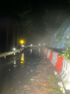
This area got the heaviest rain.
Light drizzle alternating with occasional bursts of larger raindrops falling hard,
repeating over and over.
The large drops might actually be water falling from the trees when the wind blows.
I applied a thick coat of Wako's (Japanese automotive care brand) sunscreen to my arms exposed from my short-sleeve jersey.
Not for sun protection, but because it repels water.
Except for cold winter rain, a rain jacket makes the inside so humid that I ride better with bare arms.
I threw on a wind vest with waterproof spray applied over the jersey and also added a simple fender mounted on the saddle rail.
When the heavy rain started, the feel and sound of the raindrops hitting the vest was pretty intense.

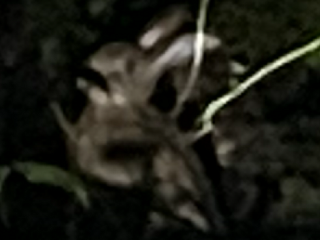
I encountered a Japanese hare on the road!
Right, I always think about this—the thing I should mount on top of the handlebar, what's it called again?
Not a GoPro, not a Delabepin, not a Scora... an action camera! That's it. I always encounter wildlife when I'm not carrying an action camera.
With the hare, we ended up facing off about 3 meters apart on the road,
staring at each other, but the moment I tried to pull out my phone,
it bolted into the forest slope like a rabbit fleeing for its life. But apparently thinking it was far enough away,
it didn't run further and just kept staring at me,
so I managed to get a blurry photo of it standing still.
There's a Japanese hare in the photo above, slightly right of center.
↑This is a crop from the full-resolution image above.
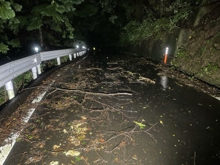
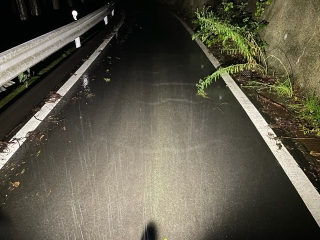
Not quite fallen trees, but thick branches littered the road everywhere.
The really dangerous ones are thin branches about the size of a finger—
step on one accidentally and your handlebars suddenly slip away from you.
So I made my descent pretty carefully and slowly.
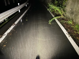
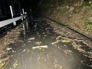
This area looks like lines in the asphalt, but those are actually wave patterns
from water flowing like a river about 1 centimeter deep.
Lighter things get swept away, so the parts turned into rivers
had no leaves or branches—actually pretty pleasant to ride through.

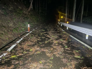
At first I thought that white thing was a sandbag,
but getting closer, it was a tree snapped at the top
hanging into the road.
The underside of the flipped leaves is whitish, so when I first saw it
I got pretty spooked.
On the descent, the really dangerous stuff is what I mentioned—
thin branches hidden among leaves.

It's hard to tell because of my phone's brightness correction,
but the fog was quite thick here and the air felt chilly.
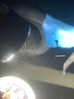
↑This was taken while stopped,
and you can see the fog flowing like it's being pulled by the light's heat.
The VOLT 6000 (action headlight) has a cooling fan that runs constantly while on,
creating airflow to the side of the unit,
so that might be the main cause of the flow.

A stone Jizo statue.
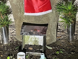
Coins for offering, check!
Branches for offering in the flower holder, check!
Someone I don't know is maintaining this.
Probably a local who's been doing this all along.

This is from around 10 PM on July 30th, in front of the torii gate at Omiya Shrine.
That day I entered Wakayama Prefecture from Kazahaki Pass
and returned to Osaka via Nabeyatoge Pass.
Before National Route 480 on the Wakayama side was rerouted to the new road,
the old road passed through in front of this Omiya Shrine torii gate,
and it became the consensus starting point among south Osaka cyclists
when timing climbs of Nabeyatoge Pass's Wakayama side.
When someone asked "what's your Nabeyatoge time?" on the Wakayama side,
it meant from the Omiya Shrine torii gate to the prefectural border marker.
Today Nabeyatoge Pass has a motorway tunnel through it,
but before that (years before the old road on the Osaka side was resurfaced),
the old road pavement was repaved once,
and everyone's times on the Omiya Shrine route clearly dropped before and after.
You should account for that, but now that whole practice
of timing from Omiya Shrine has just faded away.
Now you have to keep deliberately choosing the old road option
to even reach here.
There are signs and guides telling cars not to use this narrow road,
directing them to the new route, but the road itself is unchanged from before—
not particularly narrow at all.
Basically a pretext to keep people other than villagers from using it.
Anyway, just past Omiya Shrine
the old road merges with the new one.
Right at the merge point sits the tunnel boring through the pass.
From Omiya Shrine to the merge, traffic has dropped so much that
where trees cover the road above, you find lots of small rocks and branches.
My phone's brightness correction is so aggressive that when there's a light source,
it captures things quite bright, but the actual road is almost pitch black.
↑The usual spot.
Whether on the Osaka or Wakayama side,
this is where the summit time is recorded as the goal.
A little way down toward the Wakayama side from here
the road widens as if for a bus turnaround,
and there's a large sign saying "Nabeyatoge Pass,"
but I usually exit on the Osaka side summit,
so I never get a photo of it.
So I'm shamelessly linking to the article on Nabeyatoge-st's blog that has that photo (→here).

A little further down the Wakayama side,
there's a sign like this.

This is from a different day, July 21st around 1:20 AM.
The location is an iron bridge on the Wakayama side old road near the finish of Kisami Pass.
By the way, the spot before this bridge is (→here).

The signs from the Environmental Agency and the prefecture seem to use the same format.
This one was made before the 2001 central government reorganization,
so it says Environmental Agency, not Environmental Ministry.
So the Jizo on the Osaka side of Nabeyatoge that I saw when descending on July 30th
had flowers in it, though they were wilted.
You can't make it out in the photo, but around the back of the tea cup
there were about four 100-yen coins (I didn't count exactly, might have been more)
left as offerings.
↑This is around 3:30 AM on August 25th.
Light rain was falling but it was hot, so
I climbed thinking "I wish it would rain harder."
Right now the electronic signboard and thermometer at the summit are broken or unplugged—
the sign has a blue cover over it.
When it was powered on, you could faintly hear a refrigerator-like humming sound
(especially noticeable in the complete silence of night),
but now that's gone too.
Outside this photo's frame, a small red light flickers at the top of the signpost pole,
suggesting the surveillance camera might be on a separate power source.
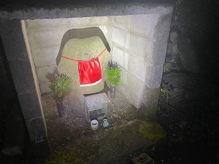
This Jizo I photographed on the way back.
This Koyamaki cypress (I think) is probably the same one as September 20th.
Since the coins were gone,
I like to believe they were used to buy new offerings.
This shrine, whether by JIZOU power or what,
doesn't grow moss inside—it stays white—
so when you shine a light on it, the ceiling glows like there's a light fixture up there.
Also, the reason I don't crash on Nabeyatoge Pass is definitely thanks to JIZOU power.
My daily behavior is bad (I'm aware), so it must be.
There's a reason I did something this reckless, but I'll write about that in another post.

This area got the heaviest rain.
Light drizzle alternating with occasional bursts of larger raindrops falling hard,
repeating over and over.
The large drops might actually be water falling from the trees when the wind blows.
I applied a thick coat of Wako's (Japanese automotive care brand) sunscreen to my arms exposed from my short-sleeve jersey.
Not for sun protection, but because it repels water.
Except for cold winter rain, a rain jacket makes the inside so humid that I ride better with bare arms.
I threw on a wind vest with waterproof spray applied over the jersey and also added a simple fender mounted on the saddle rail.
When the heavy rain started, the feel and sound of the raindrops hitting the vest was pretty intense.

I encountered a Japanese hare on the road!
Right, I always think about this—the thing I should mount on top of the handlebar, what's it called again?
Not a GoPro, not a Delabepin, not a Scora... an action camera! That's it. I always encounter wildlife when I'm not carrying an action camera.
With the hare, we ended up facing off about 3 meters apart on the road,
staring at each other, but the moment I tried to pull out my phone,
it bolted into the forest slope like a rabbit fleeing for its life. But apparently thinking it was far enough away,
it didn't run further and just kept staring at me,
so I managed to get a blurry photo of it standing still.
There's a Japanese hare in the photo above, slightly right of center.

↑This is a crop from the full-resolution image above.


Not quite fallen trees, but thick branches littered the road everywhere.
The really dangerous ones are thin branches about the size of a finger—
step on one accidentally and your handlebars suddenly slip away from you.
So I made my descent pretty carefully and slowly.


This area looks like lines in the asphalt, but those are actually wave patterns
from water flowing like a river about 1 centimeter deep.
Lighter things get swept away, so the parts turned into rivers
had no leaves or branches—actually pretty pleasant to ride through.

At first I thought that white thing was a sandbag,
but getting closer, it was a tree snapped at the top
hanging into the road.
The underside of the flipped leaves is whitish, so when I first saw it
I got pretty spooked.

On the descent, the really dangerous stuff is what I mentioned—
thin branches hidden among leaves.

It's hard to tell because of my phone's brightness correction,
but the fog was quite thick here and the air felt chilly.

↑This was taken while stopped,
and you can see the fog flowing like it's being pulled by the light's heat.
The VOLT 6000 (action headlight) has a cooling fan that runs constantly while on,
creating airflow to the side of the unit,
so that might be the main cause of the flow.

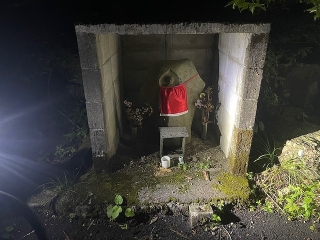
A stone Jizo statue.

Coins for offering, check!
Branches for offering in the flower holder, check!
Someone I don't know is maintaining this.
Probably a local who's been doing this all along.

This is from around 10 PM on July 30th, in front of the torii gate at Omiya Shrine.
That day I entered Wakayama Prefecture from Kazahaki Pass
and returned to Osaka via Nabeyatoge Pass.
Before National Route 480 on the Wakayama side was rerouted to the new road,
the old road passed through in front of this Omiya Shrine torii gate,
and it became the consensus starting point among south Osaka cyclists
when timing climbs of Nabeyatoge Pass's Wakayama side.
When someone asked "what's your Nabeyatoge time?" on the Wakayama side,
it meant from the Omiya Shrine torii gate to the prefectural border marker.
Today Nabeyatoge Pass has a motorway tunnel through it,
but before that (years before the old road on the Osaka side was resurfaced),
the old road pavement was repaved once,
and everyone's times on the Omiya Shrine route clearly dropped before and after.
You should account for that, but now that whole practice
of timing from Omiya Shrine has just faded away.
Now you have to keep deliberately choosing the old road option
to even reach here.
There are signs and guides telling cars not to use this narrow road,
directing them to the new route, but the road itself is unchanged from before—
not particularly narrow at all.
Basically a pretext to keep people other than villagers from using it.

Anyway, just past Omiya Shrine
the old road merges with the new one.
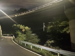
Right at the merge point sits the tunnel boring through the pass.
From Omiya Shrine to the merge, traffic has dropped so much that
where trees cover the road above, you find lots of small rocks and branches.
My phone's brightness correction is so aggressive that when there's a light source,
it captures things quite bright, but the actual road is almost pitch black.

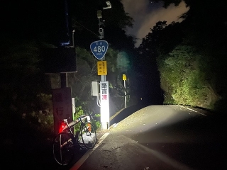
↑The usual spot.
Whether on the Osaka or Wakayama side,
this is where the summit time is recorded as the goal.
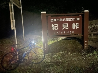
A little way down toward the Wakayama side from here
the road widens as if for a bus turnaround,
and there's a large sign saying "Nabeyatoge Pass,"
but I usually exit on the Osaka side summit,
so I never get a photo of it.
So I'm shamelessly linking to the article on Nabeyatoge-st's blog that has that photo (→here).

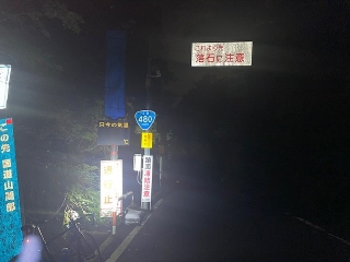
A little further down the Wakayama side,
there's a sign like this.

This is from a different day, July 21st around 1:20 AM.
The location is an iron bridge on the Wakayama side old road near the finish of Kisami Pass.
By the way, the spot before this bridge is (→here).


The signs from the Environmental Agency and the prefecture seem to use the same format.
This one was made before the 2001 central government reorganization,
so it says Environmental Agency, not Environmental Ministry.

So the Jizo on the Osaka side of Nabeyatoge that I saw when descending on July 30th
had flowers in it, though they were wilted.
You can't make it out in the photo, but around the back of the tea cup
there were about four 100-yen coins (I didn't count exactly, might have been more)
left as offerings.

↑This is around 3:30 AM on August 25th.
Light rain was falling but it was hot, so
I climbed thinking "I wish it would rain harder."
Right now the electronic signboard and thermometer at the summit are broken or unplugged—
the sign has a blue cover over it.
When it was powered on, you could faintly hear a refrigerator-like humming sound
(especially noticeable in the complete silence of night),
but now that's gone too.
Outside this photo's frame, a small red light flickers at the top of the signpost pole,
suggesting the surveillance camera might be on a separate power source.

This Jizo I photographed on the way back.
This Koyamaki cypress (I think) is probably the same one as September 20th.
Since the coins were gone,
I like to believe they were used to buy new offerings.
This shrine, whether by JIZOU power or what,
doesn't grow moss inside—it stays white—
so when you shine a light on it, the ceiling glows like there's a light fixture up there.
Also, the reason I don't crash on Nabeyatoge Pass is definitely thanks to JIZOU power.
My daily behavior is bad (I'm aware), so it must be.